Sunday, November 25, 2007

Cherry Creek Asbestos Mining Operations

11/25/07
This morning we returned to the Asbestos Mine workings we'd passed yesterday on Cherry Creek Road. Jean and Larry were going to go with us this morning, but Murphy's Law came into play when were following behind them in our Jeep and noticed something hanging from beneath their Jeep. We called ahead to them on the radio and they pulled over to check. Unfortunately, it turned out to be a shock absorber hanging loose, one of the brackets holding it had broken. Since this wasn't going to be an easy trail fix, they had to turn back. We missed you guys!
Ralph & I decided to go on and make the trip. It was a fabulous morning, clear, crisp and cold, just the way we like it. We stopped just below Board Tree Saddle to take a photo of the mine off in the distance. We could also see a road that once ran from the top of the mountain, straight on down to the mine. It might have been used at one time to run a cable to haul ore carts up the mountainside. It would have been too steep for any kind of motor vehicle traffic, but possibly a mule could have made the trek.  
We parked the Jeep at the bottom of the mountain where the mines and workings are located and hiked up the steep trail leading to the mine works. Chunks of asbestos littered the entire area. Asbestos tailings were cascading down the steep hillsides. The ruins of the old mining site were quite extensive, mostly old boards, iron girders and heavy iron beams. There were a few rusted pieces of equipment left near the mining site. As best as we can tell by research, the mines were last in operation in the 1950s. We could see huge blocks of Asbestos still remaining in the mountainside. The walls of the workings were even made from Asbestos blocks, cut to fit and used to hold up the walls of the structures. After exploring the remains, we took a trail leading along a narrow ledge on the side of the mountain just past the workings and came across several mine adits. Since we weren't expecting to see actual tunnels, we didn't have our flashlights with us, so we only went into the tunnels a short distance. Even treading carefully, we could see Asbestos dust and fibers floating in the air inside the mine shafts. It's hard to imagine working in that environment all day long, every day.
Hiking up what was left of the road past the mines, we could see the road we'd spotted earlier from up near Board Tree Saddle. There were more piles of tailings and more Asbestos deposits, but we didn't explore any further today, we'll save that for another trip when we return with Jean & Larry & flashlights.
The peaceful shady glades along the trail were beautiful this morning. As we ate our sandwiches, we enjoyed the natural surroundings. Sunlight filtered through the trees, making dappled patterns on the rocky terrain. Cold mountain breezes were whispering through the pines...I know that sounds a bit trite, but the sound of the pine trees is truly a whisper. If we're really quiet and still, perhaps they'll whisper their secrets.  

Saturday, November 24, 2007

Cherry Creek Road completed.

 11/24/07
We headed out early this morning to meet Jean & Larry up near Workman Creek. They had gone out well before daylight, hoping to see some Elk as they came to feed at an apple orchard up near Aztec Peak. We didn't want to leave quite that early since we were obligated to take care of Bailey, (our Schnauzer boss) before we left the house. Larry & Jean didn't have any luck spotting Elk, better luck next time. Eventually, we're bound to see them, everyone tells us they're there, although I think they're probably mythical creatures, like Unicorns and Big Foot.
After meeting up with Jean & Larry, we headed to Young to take Cherry Creek Road all the way to Board Tree Saddle. We've done the other half of Cherry Creek Road, beginning from SR 288 and coming out at Board Tree Saddle, but we've never been on the other half of the trail.
Jean & I had to humor our husbands as they played hide and seek Jeep. Larry was leading, then he pulled off the road and hid Old Blue behind some bushes....then it was Ralph's turn, as we saw Old Blue pull up behind us, Ralph sped up until he too could pull off the road and hide our Old Peep's Jeep from Larry. It worked, we saw them go speeding past our hiding place. After wondering where each other was for a few minutes, we eventually met up at FR 54, to begin our trip on Cherry Creek Road. I'm convinced, boys will be boys, now and forever.
The trail headed out through a diverse landscape, from rolling meadows and pastures to steep hillsides, sheer cliffs and deep canyons. The scenery was ever-changing, and ever beautiful.
We stopped along the way to check out what appeared to be an old Asbestos mill. There wasn't much left but we could still see the remnants of the mill along with an assayer's office and some housing. Larry found some hard rock core samples near the old assayers office. We always find it interesting to speculate about the people who once worked in these places. It had to be terribly hard work, and certainly a very unhealthy environment to work in. From what we've read, Asbestos miners didn't live to a ripe old age, often developing a variety of deadly lung ailments.
We crossed Cherry Creek and found a beautiful spot right next to the creek that we all agreed would be a perfect camp site, so we'll certainly make future plans to return and spend a night or two.
We also spotted another much larger Asbestos operation up on a hillside, but since we were nearing the end of our trip and Board Tree Saddle, we didn't have time today to check it out.  We're hoping to head back, possibly tomorrow to explore it. It looks like an interesting place. Now we can say we've run Cherry Creek Road in its entirety, quite and accomplishment for all of us. It was another great run and a nice day spent in the company of good friends. Now if Jean and I can figure out how to keep the "boys" from playing hide and seek Jeep, all will be well.


Monday, November 19, 2007

Who needs a night light, we've got each other.

 11/19/07
We returned to the Workman Creek area to check out some more abandoned Uranium Mines, the Lucky Stop and the Hope Mining Claims. It was a nice hike through the pine forest to reach the mines. As we approached them, there was a distinctive odor of rotten eggs in the air, not a good sign. The odor is caused by  Hydrogen Sulphide, a gas that forms when ground water and sulphides are present in mines and caves...BAD AIR!  We knew not to take any chances with bad air, so we just went far enough in to take some quick photos and got out. They're a spooky looking group of mines, one of them has a vertical shaft dropping to unknown depths about twenty-five feet in from the main adit. The walls are a sickly yellow green color with white crystals forming along the way from water seepage. No bats were seen clinging to the ceilings, also not a good sign. We could see that there had been lots of digging in the surrounding area and we've read that there were at least 17 mines and claims in the Workman Creek group of mines. There were no timber supports to be found anywhere, all the mines had been carved into layered shale-type rock, an engineering marvel to see. The tunnels were mostly square, unlike the rounded tunnels we've seen in other mines, probably because the rock they were carved into seemed to fracture into squares naturally.  
We checked out another road on the way home, FR488, it heads out toward some really deep canyon drop-offs and rocky cliffs, I wasn't feeling particularly adventurous given the deep chasms and soaring heights, so we called it a day and headed home. 
After visiting the Uranium Mines, we'll probably glow in the dark, ah well, who needs night lights, we've got each other. 


Saturday, November 17, 2007

Aztec Peak and more
11/17/07
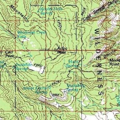
Awesome, fantastic, spectacular, serene, beautiful .... it's hard to find adjectives to describe the area we visited today. The road we took runs high up into the Sierra Ancha Mountains, bordering on the Sierra Ancha Wilderness. Riding up the road early this morning was a treat for the senses. Cool. crisp, pine scented air, sunlight filtering through the trees, dappling the road in front of us. 
On the way up, we paused to take some pictures of an abandoned Uranium mine. Uranium was heavily mined in the area up until the late 1950s. The adit was boarded up, with warning signs posted, but we managed to squeeze the camera through an opening to take a few photos. Supposedly, the surrounding areas are fairly radioactive, so overnight camping is prohibited. (we can't help but wonder if the local critters glow in the dark at night.)   
We stopped further up, to check out the waterfall, unfortunately, there hasn't been a lot of rain recently, so Workman Creek wasn't flowing full force as it toppled over the falls, falling to a depth of about 200 feet. Near the falls but high above are the remains of some ancient Indian cliff dwellings, but the climb looked to be one that you'd want some special equipment to make. Slippery shale slopes aren't for the casual climber...hmmm say THAT three times fast....
Proceeding up the road, we stopped at an old CCC (Civilian Conservation Corps) fish hatchery, a pretty spot where we could hear water meandering down the rocky creek below.
Our next stop was at the top of Aztec Peak. The fire tower up there is listed in the National Historic Lookout Register. The views from all sides were absolutely breathtaking. Aztec Peak's elevation is 7748 feet, making it the highest point in the Tonto National Forest. Just below the tower is a beautiful vantage point, someone, perhaps a bored fire tower lookout person has made what the locals call, Flintstones' living room. There are easy chairs, a table and chairs, a fireplace, all made from stacking flat sandstone rocks. It's quite a sight to see. The Coon Creek Fire which burned 9644 acres back in 2000 burned many of the large pine trees in the area, their remains can still be seen. Mother Nature has a way of healing her forests, so you can also see the new growth of young pine trees throughout the area. 
On our way back down the mountain, we made a stop at the old Murphy Ranch, now Haldi Ranch Apple Orchard. The log home and cabins are beautifully rustic, but the orchard looked like it had seen better days. 
The trip was perfect, thanks Larry & Jean for showing us such a beautiful spot. 


Friday, November 16, 2007

Dam it!

11/16/07

We decided on a bit of a walk today to explore the immediate area around Roosevelt Dam. Perfect weather, clear skies and temperature right at 60ยบ made for great walking. Roosevelt Dam is quite an impressive structure. Once the world's tallest masonry dam, it is named after President Theodore Roosevelt, who was instrumental in approval of the Federal Reclamation Act of 1902, and who dedicated the original dam named in his honor in March 1911. Forty one people were killed between the years 1904 and 1911 during construction of this massive project.

Due to fears of flooding, in 1996 a $430 million modification project was completed that raised the height of the dam to 357 feet and expanded the lake's storage capacity by 20 percent, enough for one million more people. This 77-foot increase offers six Valley cities 304,729 new acre-feet of water storage to the dam and, for the first time, provides SRP with substantial amounts of flood control and Safety of Dams storage space. The dam has hydrogeneration capacity of 36,000 kW. (Salt River Project Statistics)

Below is a statement from President Roosevelt given during the dedication ceremony of the opening of Roosevelt Dam

"If there could be any monument which would appeal to any man, surely this is it. You could not have done anything which would have pleased and touched me more than to name this great dam, this reservoir site, after me, and I thank you from my heart for having done so... As soon as it was done (the National Reclamation Act signed into law), ...I said, now I want this work divided fairly... and as Arizona and New Mexico have not any senators or congressmen and as I raised three-fourths of my regiment (Rough Riders) in New Mexico and Arizona, I will take their place, and now I want to see that they get a fair deal."

On March 18, 1911, at 5:48 p.m. Roosevelt pressed a button to allow the release of water from the reservoir. 

Roosevelt Dam forms Roosevelt Lake, with a length of 22.4 miles and a shoreline of 128 miles

 
Standing alongside Roosevelt Dam this morning, we could almost imagine Teddy Roosevelt as he gave his rousing speech while the crowd roared with excitement. His wonderful legacy lives on today.


Monday, November 12, 2007

Saguaro Mine, A gem of a find!

11/12/07

What a surprising day this turned out to be. We've made several attempts to locate Saguaro Mine, so this morning we thought we'd give it another try. The road leading to the old mine is rocky, washed out, really bumpy and quite a challenge. We took A-Cross to FR267 and continued on FR267 as far as we could safely go in the Jeep. From there we decided since the temperatures were still cool, we'd attempt to make the hike up into the mountains. There were ATV tracks leading in, and we could see evidence of vehicle damage as they dragged over rocks. We were glad we parked and didn't attempt to drive it. It was quite a strenuous hike, uphill all the way, clambering over rocks and slippery sand. I wasn't crazy about the drop-offs along the narrow road, even walking, they challenged my fear of heights, but we made it. We could see evidence of some sort of mining having been done as we approached the top of the mountain. One area in particular caught my attention, it looked like a square vertical mine shaft had been filled in with rocks, sand and dirt. Ralph wanted to climb up to the mountain top so I stayed behind to catch my breath and explore the area of the filled mine. I was randomly digging in the loose sand, not looking for anything in particular when I saw something shining in the sand. It looked like an old pop-top from a can. I pulled it out of the shallow hole and much to my surprise...it was a ring!  It's a very small-sized ladies white gold, diamond ring. It barely fits my pinkie and I've got fairly small fingers. The diamond looks to be about 1/4 karat and the ring itself is marked 18K with a very intricate filigree pattern. I called Ralph on the walkie-talkie and told him to come on down to see what I found! It looks to be pretty old, but it sparkled like new when we got it home and cleaned it. We can't imagine how it got to the old mining site...perhaps a lady miner lost it, or maybe a miner had it in his pocket as a gift for his lady? I wish we had some way of tracing the history, but I suppose we'll have to just speculate. Even though there aren't any remains of Saguaro Mine, the trip proved to be very worthwhile! We've metal detected all over the place since moving to Arizona, with little success. This is the first time we've found anything of real value and we didn't even bring the metal detector with us. We're glad to mark Saguaro Mine off of our places we want to find. It's disappointing there aren't any remains, but we do feel like someone had left a treasure for us to find.


Sunday, November 11, 2007

Reno Pass FR491 to FR524

11/11/07

What an awesome ride and hike this morning! We decided since the weather is so terrific we'd take a hike up Reno Creek this morning. It's an interesting area to explore, home to a lot of early Arizona History. Reno Creek is a dry riverbed that runs through Reno Pass near the site of Camp Reno, a site that was used by the military during the late 1800s as a fort to protect early settlers and miners from Apache raiding parties. The soldiers built a road from the Phoenix side of the mountains, beginning at Fort McDowell and ending near Tonto Basin.  It's hard to imagine how the road was built through such rugged terrain. The road is still there, but from what we've been told, it's not for the faint-hearted, there's little clearance from the tires to the dizzying 600 foot drop-offs. Ralph hiked up the road a little ways and speculated that it could be driven using care, but not without a lot of complaining and audible gasping from me. The Forest Service has closed the road on the Phoenix side of the mountains to give the area a chance to recover from a devastating forest fire a few years ago, so even if we did make the trip, we'd have to turn around and head back from whence we came...not an appealing ride to make both coming and going.
We hiked a mile or so up the dry riverbed admiring the beautiful scenery along the way. By the time the sun was high in the sky, it was beginning to warm up, so we headed back. We'll return to Reno Creek and hopefully hike further up next time, maybe in the dead of winter when the temperatures stay cold. Perhaps we can find remnants of one of the many Indian skirmishes that took place in this area.
We finished up the trip with lunch at Butcher Hook Restaurant in Tonto Basin, sated, stuffed and happy, we headed home.

The Search is on...AGAIN

11/10/07

Another trip up to FR609 to look for the cave our neighbor told us about. We spoke with him again and got what he called "more specific" directions this time. The last directions were, "turn at the big Black Walnut tree about seven miles from the main highway"...uh huh...we searched and didn't find it. This time he said to "turn at the big Black Walnut tree about 75 yards from the road and two to four miles from the main highway." Well, if there's a Black Walnut tree anywhere along that road, we sure didn't find it, nor did we find the cave we were looking for.

Time wasn't wasted however, the air was cool, crisp and pine-scented and we got to see several Mule Deer and some Wild Turkeys. We also checked out a "road" Ralph spotted...not much of a road, but it might be a good place to return to and take a pine forest stroll sometime.

Oh well, we'll try again, they say half the fun is in the search....